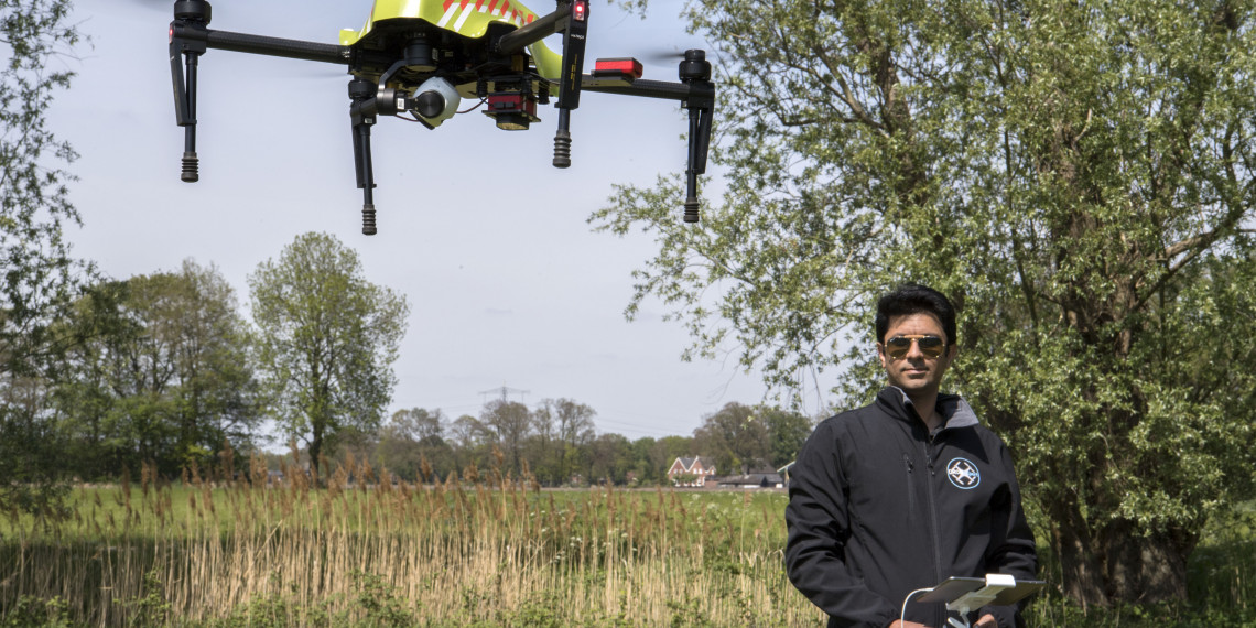
‘We are lucky that they cut the grass recently, so we can actually walk through the field,’ says ITC researcher Hamed Mehdipoor. ‘Lucky’ we are - to be here in Twente’s countryside on this sunny day -, but it was in fact Mehdipoor and his colleague Raul Zurita-Milla who helped to decide this was the best moment to cut the said grass. The scientists are part of a collaboration between the University of Twente, Hof van Twente, the drone company Robor Electronics BV, the machinery company Timmerman BV and three young farmers, all working together to test new technology for precision farming, a method that could save both the environment and money.
'Manure is a big problem in the Netherlands and we need to be careful about how it’s managed'
How much manure is too much manure?
‘The core of the project is manuring and organic fertilization of grasslands,’ explains Zurita-Milla. ‘There is a lot of dairy production here in Twente. To sustain the cattle, we need a lot of grassland and that land needs to be fertilized, for which farmers use manure. At the same time, manure is a big problem in the Netherlands and we need to be careful about how it’s managed. Using manure, we are compromising the soil, because it contains a lot of antibiotics, heavy metals, hormones, pesticides and so on. All of that goes into the soil. It is an environmental hazard. If we use less, but keep the production, it is a win win situation.’

Determining the optimal amount of manure and the best time to apply it is a challenge, though. One that the UT researchers aim to solve, says Mehdipoor. ‘We are collecting data using drones and multi- and hyperspectral sensors, we will analyze it and provide farmers with information on when and how much manure to apply. This is important because if the timing is off, you won’t get the optimal amount of yield.’ The same goes for mowing the grass. ‘If you do at the right moment, you are able to get the ideal levels of protein and fiber, meaning the best possible feed for farm animals. The quality of grass is crucial. It affects the cows, which affects their milk and therefore the entire dairy market.’

Small land, big differences
These are the reasons to focus on precision farming and, in this case, to use drones, satellite imaging and ground sensors. Every couple of weeks, if the weather permits just like today, the researchers fly their drones over the ‘test’ field to collect data. They use multispectral, hyperspectral and RGB cameras, which can record information that our eyes cannot see. Combined with ground data, they are able to find ‘the perfect time and place’. ‘Even though it’s a small area, you can see that there are big differences in the soil type,’ says Mehdipoor, pointing to a neighboring field that was recently plowed, exposing surprising colour variations on the narrow piece of land.
‘The land is indeed heterogenous,’ says Zurita-Milla. ‘Yet, now the common practice is to simply bring a tractor and apply fertilizer everywhere on the field, even though you don’t need to put it everywhere. Farmers do it this way because it is easier and also because they don’t have the information to make other decisions. They don’t know which unit on their land should be fertilized and which shouldn’t.’

Advisory system for farmers
Not for long. The researchers are testing how different amounts of manure impact the land. ‘You can see that they applied different amount of fertilizer on each row,’ remarks Mehdipoor as we make our way toward the thermometer and soil moisture meter sticking out of the field. Yes, this particular part of land has received a generous manure dose. Not a great day to wear white sneakers. It’s all for a greater purpose, of course. These field tests are necessary for the next step of the project: online advisory service for farmers.
'We are beginning in the Netherlands, but this is technology that could be use on much bigger fields in countries such as Canada'
‘Based on the data we collect now, we will create computer-based models using machine learning,’ says Mehdipoor. ‘These models will be able to show when and where to apply fertilizer and mow the grass. We plan to offer this as an advisory service for farmers. In the future, they would only need to fly the drone to get the current data, upload it and see exactly what to do. This would save them money, and save the environment at the same time.’
The future
The drones first appeared in Bentelo about six months ago and the data collection will continue until the end of summer. Afterwards it will be time for careful data analysis. That might not be the end, though. ‘This project focuses on grasslands, but farmers have already expressed their interest in testing for different crops,’ says Mehdipoor, suggesting this could be the start of the next generation of farming. ‘We are beginning in the Netherlands, but this is technology that could be use on much bigger fields in countries such as Canada, where it’s difficult for farmers to constantly check their whole vast land.’


