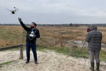
‘Please shout if you spot something interesting?', researcher Panagiotis Nyktas asks, as he concentrates on sending a drone into the air. As soon as the machine has reached a sufficient height, he takes a quick look at the little screen next to him, on which three orangey-yellow figures appear: Nyktas himself, MSc student Douglas Gichangi (Natural Resources Management) and U-Today's reporter, captured by an infrared camera attached to the drone. Good, that camera works properly.
 Preparatory field trip
The three of us are in the middle of the Engbertdijksvenen nature reserve. It is the setting for a pilot project by the UT and the province of Overijssel to map the local wild boar population, using advanced technology and intelligent data collection and analysis. The animals will remain undisturbed on this cold December morning, as this field trip is only for preparatory work for the project, such as test flights with the drone and further exploration of the site.
Engbertdijksvenen is one of the last remaining wet peat-swamps in the Netherlands, surrounded by dry heathland and woodland. Until recently wild boars were not allowed to live here - the province of Overijssel had a 'zero-standard policy', in 2019 expended to a 'zero damage policy - but the animals have been thriving in and around this Natura2000 area. Just last month, a hiker photographed a group of about fifteen to twenty of them, not far from the bird-watching hut where Nyktas and Gichangi are carrying out their drone test flights today.
Risks and a disaster scenario
A daytime sighting of such a large group of wild boars is quite rare; the animals are mostly active at night. Partly because of this, it is difficult to determine exactly how many boars live in Engbertdijksvenen - their total number here is estimated at fifty to sixty. This uncertainty about their numbers makes it difficult to determine whether a blind eye can be turned to what numbers of animals, and at which population size intervention is inevitable because of environmental nuisance.
With a weight of one hundred to one hundred and fifty kilos and a strong appetite, wild boars pose a risk to traffic and agriculture. With their rooting they can destroy an agricultural plot overnight. But they are feared even more as spreaders of infectious animal diseases. African swine fever, in particular, is currently a major concern. At the moment The Netherlands is free of this virus, but bordering Germany already has over 250 confirmed cases of infected wild boar. To emphasize how serious this is: our neighbours to the east are deploying the army to track down carcasses in the woods and are erecting fences along the entire eastern border to stop migrating Polish wild boar. Everything to prevent the catastrophic scenario of the German pig herds being contaminated.

Jogger as a target
This morning in Engbertdijksvenen there is no sign of that threat. Apart from a hefty buzzard, all animals seek shelter from the strong easterly wind - there doesn't seem to be a living soul around. Moments later Nyktas and Gichangi are lucky after all: a jogger defies the cold. Together with his dog he forms a perfect 'target' for a test flight with the drone.
Concentrated Nyktas flies the buzzing machine, while Gichangi uses a small monitor to check whether the video recordings are coming in correctly. The jogger’s movements and even his dog’s are perfectly followable. Even for a layman the images are evidence enough that drone recordings can be made suitable for automatic classification, as DesignLab students concluded during an earlier study. The recently added infrared camera also allows to keep track of the boars when they hide in or under the bushes. When these images are linked to geo-data, movement patterns and locations can be traced fairly precisely.
 Challenging
‘Data collection is not the biggest challenge of this project', says Nyktas, who is an ecologist at the ITC faculty. ‘The trick is to collect the right data; to come to an algorithm that recognises which images are of wild boar and which are not.’ This applies to both the drones and the static camera traps that will be used to monitor Engbertdijksvenen’s wildlife. One of the main tasks is to explore if data collection can be analysed in such a way, with use of AI, that only relevant data (about boars) is collected, and the rest is not. Separating relevant data from other camera data is one of the most time consuming tasks of such work. The main analysis comes after that, aiming to estimate the number of these animals. The less irrelevant data a dataset contains, the easier or faster the analysis.
Later, the modeling results are compared with data from the hunters of the local fauna management unit – which are 'amazingly accurate', according to Gichangi, who analysed the data. In this way, the data collection can be finetuned more and more. The final aim of the project is to compare and propose the best methods for monitoring the wild boar population here, but also in other places; to come to a field data collection and analyses protocol.
Learning and experimenting
 Although still a pie in the sky, Nyktas can already see how relevant all-automatic observations of flora and fauna will be possible in the near future, with the level of detail of drone recordings and at the same time the wide range of satellite images. Gichangi has no difficulty imagining such future scenarios either. He vividly explains how automatic image collection and analysis could be of great value for wildlife protection in his home country Kenya, where the coexistence of people with elephants or big cats is not always harmonious.
For the time being, however, it is still a matter of learning and experimenting here in Engbertdijksvenen – masked, because as we experienced this morning: mouth masks do not only protect from spreading virus particles, they also protect from sub-zero wind chills.


 Preparatory field trip
  Challenging


